Prevention
-
What is it?
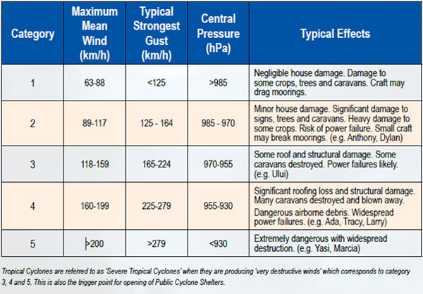
Category
What are the local risks?
The Whitsunday Region has a very high risk of being impacted by cyclones including storm tide during the cyclone season which officially runs from 1 November to 30 April. Also, the Whitsunday Region is largely a coastal and island-based community, with several low-lying areas at significant risk from storm tide. Inland areas such as Collinsville are not at risk from storm tide.
Useful Links
-
What is it?
A storm surge is a rise above the normal water level along a shore resulting from strong onshore winds and / or reduced atmospheric pressure. The combination of storm surge and normal (astronomical) tide is known as a ‘storm tide’. The worst impacts occur when the storm surge arrives on top of a high tide and when this happens, the storm tide can reach areas that might otherwise have been safe. On top of this are pounding waves generated by the powerful winds.
What are the local risks?
The Whitsunday Region has a very high risk of being impacted by cyclones including storm tide during the cyclone season which officially runs from 1 November to 30 April. Also, the Whitsunday Region is largely a coastal and island-based community, with several low-lying areas at significant risk from storm tide. Inland areas such as Collinsville are not at risk from storm tide.
In January 2014, Cyclone Dylan (Category 2) crossed the Whitsunday coast near Hydeaway Bay, also on the day of a king tide. The day prior and the day that the cyclone crossed the coast, widespread storm tide of up to 0.5metres of water above the usual king tide level was experienced across the region, inundating streets and foreshores across Bowen, Cannonvale, Airlie Beach and Wilson Beach.
The Whitsunday Disaster Management Group initiated over 100,000 Emergency Alert text messages and phone calls to warn the community of the risk, as worst case scenario predictions of the storm tide from the Bureau of Meteorology were between 1.2m and 2.0m across the Whitsunday coast depending on the time and location of the cyclone crossing. Fortunately, the cyclone crossed at low tide.
Useful Links
-
What is it?
Severe thunderstorm and severe weather warnings are issued by the Bureau of Meteorology. In active months, especially November to April, many of these warnings are issued for parts of the Whitsunday Region, often multiple times each day. Severe thunderstorms and severe weather rarely leads to the activation of the Whitsunday Disaster Management Group or the Whitsunday Disaster Coordination Centre. Although these events can be dangerous, and it is important that the community is warned and aware of the risks and take the necessary precautions, they rarely result in a large scale disaster event that requires a significant coordinated response and recovery effort.
What are the local risks?
Severe Thunderstorms
While the Whitsunday Region experiences many thunderstorms, more intense thunderstorms are referred to as severe thunderstorms. Severe thunderstorms can cause significant localised damage due to damaging wind gusts, large hail, tornadoes and flash flooding.
The Bureau of Meteorology issues Severe Thunderstorm Warnings to alert communities of the threat of these more dangerous thunderstorms.
Severe Weather
Severe weather warnings are provided for potentially hazardous or dangerous weather that is not solely related to severe thunderstorms, tropical cyclones or bushfires.
The Bureau of Meteorology issues severe weather warnings whenever severe weather is occurring in an area or is expected to develop or move into an area. The warnings describe the area under threat and the expected hazards. Warnings are issued with varying lead-times, depending on the weather situation, and range from just an hour or two up to about 24 hours.
Useful Links
-
What is it?
A flood occurs as a result of excess rainfall in a river, creek or storm water drainage catchment that exceeds the ability of the catchment to contain the rainfall in the natural or man-made water flow paths. Flooding can be minor such as road inundation, or moderate to major when houses become inundated or areas evacuated.
What are the local risks?
The Whitsunday Region has a high risk of being impacted by flooding primarily during the wet season which officially runs from 1 November to 30 April. Flooding may or may not be associated with cyclones or severe weather events and can occur at any time of the year.
Councils Natural Disaster Risk Management Report advises that flooding in the Whitsunday Region can result from one or more of the following, which may occur in combination:
- Flooding in the catchments of the major river systems in the region, namely the Don River; the Proserpine River and its tributaries; the Gregory River; and the Andromache/ O’Connell Rivers
- Flooding in the catchments of the major river systems in the region, namely the Don River; the Proserpine River and its tributaries; the Gregory River; and the Andromache/ O’Connell Rivers
- Major flooding in the Don River occurs frequently and minor flooding in Euri Creek and the Elliot River to the north of Bowen
- Flash flooding following intense short period rainfall in smaller catchments such as Airlie Creek and Campbell Creek, which creates localised high risk due to high velocity flows and the lack of warning time
- In the case of flooding associated with tropical cyclones, flooding of low lying areas close to the shore line can result from a combination of high tide and storm surge (together referred to as storm tide)
Official road closures are listed on the State Government QLD Roads website
Useful Links
-
What is it?
Bushfires and grassfires are common throughout Australia. Grassfires are fast moving, passing in five to ten seconds and smouldering for minutes. They have a low to medium intensity and primarily damage crops, livestock and farming infrastructure, such as fences. Bushfires are generally slower moving but have a higher heat output. This means they pass in two to five minutes, but they can smoulder for days. Fire in the crown of the tree canopy can move rapidly.
(Definition from Geoscience Australia).
What are the local risks?
Bushfires can happen here although we live in the Wet Tropics with humid conditions. They may be started through arson (deliberately lit), carelessness (e.g. discarded cigarettes, sparks from machinery, unattended fires), lightning, as the result of an accident or very rarely, as the result of a controlled / prescribed burn. If you light a fire, on purpose or accidentally, you are responsible for controlling it.
If there is a long spell of hot, dry weather and it's windy, the fire risk increases. Generally, the fire season in Central and North Queensland is through the winter (dry season) and spring months. Information about fire risk and fire danger periods will be issued by fire authorities as required.
In the Whitsunday Region, there are extensive areas of medium bushfire hazard and several smaller areas or high bushfire hazard.
You don’t have to live in the bush to be threatened by bushfire, just close enough to be affected by burning material, embers and smoke.
Useful Links
- Rural Fire Service or read other PREPARE. ACT. SURVIVE. resources
-
What is it?
The Bureau of Meteorology defines a heat wave as three days or more of high maximum and minimum temperatures that is unusual for that location.
What are the risks?
The bulk of heatwaves at each location are of low intensity, with most people expected to have adequate capacity to cope with this level of heat. Less frequent, higher intensity heatwaves are classified as severe and will be challenging for some more vulnerable people, such as those over 65, pregnant women, babies and young children, and those with a chronic illness. Even rarer and exceptionally intense heatwaves are classed as extreme and will impact normally reliable infrastructure, such as power and transport. Extreme heatwaves are a risk for anyone who does not take precautions to keep cool, even those who are healthy.
Severe and extreme heatwaves have taken more lives than any other natural hazard in Australia's 200 year history. For example, during the 2009 Victorian bushfires, 173 people perished as a direct result of the bushfires, however 374 people lost their lives to extreme heat in Victoria in the heatwave before the bushfires.
For information on staying healthy in the heat or heat related illnesses, please visit QLD State Government website.
-
What is it?
Earthquakes are the vibrations caused by rocks breaking under stress. The underground surface along which the rock breaks and moves is called a fault plane. Earthquakes in Australia are usually caused by movements along faults as a result of compression in the Earth crust. The size or magnitude of earthquakes is determined by measuring the amplitude of the seismic waves recorded on a seismograph and the distance of the seismograph from the earthquake. These are put into a formula which converts them to a magnitude, which is a measure of the energy released by the earthquake. For every unit increase in magnitude, there is roughly a thirty-fold increase in the energy released. For instance, a magnitude 6.0 earthquake releases approximately 30 times more energy than a magnitude 5.0 earthquake, while a magnitude 7.0 earthquake releases approximately 900 times (30x30) more energy than a magnitude 5.0. Earthquake magnitude was traditionally measured on the Richter Scale. It is often now calculated from seismic moment, which is proportional to the fault area multiplied by the average displacement on the fault. The focus of an earthquake is the point where it originated within the earth. The earthquake epicentre is the point on the Earth’s surface directly above the focus.
This information has been provided by Geoscience Australia.
What are the local risks?
Earthquake risk in the Whitsunday Region is high in Queensland terms, moderate in Australian terms and low in global terms. On 18 August 2016 at 2.30pm the second largest earthquake on record in Queensland of 5.8 magnitude occurred just offshore within the Whitsunday Region, about 50 kms from Bowen. This earthquake was felt across the entire Whitsunday Region and large amounts of Queensland and was followed by over fifty (50) aftershocks.
On 16 April 2011, a significant 5.3 magnitude earthquake occurred west of Bowen and was widely felt across the Whitsunday Region, this is one of the ten (10) largest earthquakes on record in Queensland.
Useful Links
-
What is it?
Tsunami (pron’ soo-nar-meâ) is a Japanese word; tsuâ meaning harbour and namiâ meaning wave. The phenomenon is usually associated with earthquakes, landslides or volcanic eruptions in, or adjacent to oceans, and results in sudden movement of the water column. Until recently a tsunami was called a tidal wave, even though the event has nothing to do with tides.
What are the local risks?
There is little recorded history of tsunami in Australia, possibly because Australia has a relatively short history. There is evidence that the Australian coast may have experienced large tsunami during the past few thousand years, even within areas of the Great Barrier Reef. The Great Barrier Reef however is expected to provide a level of protection to the Whitsunday Region in the event of a tsunami in the Pacific Ocean.
The Whitsunday Disaster Management Group regularly receives information about undersea earthquakes and tsunamis around the world.
The recent 5.8 magnitude earthquake in 2016 just off the coast of the Whitsundays (the second largest on record in Queensland) was not large enough to trigger a tsunami warning.
Useful Links
-
What is it?
A landslide is the movement of rock, debris or earth down a slope. Landslides result from the failure of the materials which make up the hill slope and are driven by the force of gravity. Landslides are known also as landslips, slumps or slope failure.
What are the local risks?
There are areas of the Whitsunday Region which are susceptible to landslides, including areas from Cannonvale and Airlie Beach through to Shute Harbour, as well as Hydeaway Bay. These areas have sufficient slope and rainfall which elevate the risk of landslides in these developed areas.
On 30th March 2011, Hydeaway Bay was affected by landslides. This was apparently as a result of about 600mm of rainfall in the area over three (3) day period, after an already heavy ‘wet eason’.In2008, a landslide at Shute Harbour damaged half the road leading into a residential estate.
Useful Links
-
To view more risks to the Whitsunday Regional in detail view pages 6 to 28 of the Whitsunday Emergency Action Guide.